


The Urban Accessibility Explorer is an easy-to-use mapping system that measures the number of activities that can be reached by residents of specified neighborhoods within a given amount of travel time, by a particular mode and time of day.

(Updated 04/16/2015) The Metropolitan Chicago Accessibility Explorer is an easy-to-use mapping system that measures the number of activities, including various types of jobs, schools, parks, stores and libraries, that can be reached by residents of specified neighborhoods within a given amount of travel time, by a particular mode and time of day in the Chicago Metropolitan area. The results are displayed on maps that can be adjusted by scale and area. The Accessibility Explorer was developed by the Urban Transportation Center, which is a unit of the College of Urban Planning and Public Affairs at the University of Illinois at Chicago help policy makers, planners, and the general public easily evaluate how transportation system and land use change could alter accessibility.

This is an example of a new class of accessibility-based mapping tools, which also includes WalkScore and TransitScore, and the Access To Jobs Mapping System developed by the Regional Planning Association in the New York City region.
These tools help apply accessibility-based planning, which recognizes that the ultimate goal of most transport activity is access to goods and services, and that many factors can affect accessibility including the convenience, speed, and affordability of travel by various modes, transport network connectivity, land use density, and mix, and mobility substitutes such as telecommunications and delivery services.
(The post was updated to give proper credit to the developers of the app.)
FULL STORY: Metropolitan Chicago Accessibility Explorer


Transportation for Everyone
An efficient and fair transportation system must serve diverse users. The "Transportation for Everyone" rating system evaluates transport system diversity and, therefore, its ability to serve all community members.
Accessibility-Based Planning
Should society encourage parents to drive children to school rather than walk or bicycle? Should our transportation policies favor driving over walking, cycling, ridesharing, public transit and telecommuting? Probably not. There is no logical reason to favor automobile travel over other forms of accessibility, and there are lots of good reasons to favor efficient modes, so for example, schools spend at least as much to accommodate a walking or cycling trip as an automobile trip, and transportation agencies and employers spend at least as much to improve ridesharing and public transit commuting as automobile commuting.
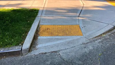
Baltimore Ordered to Improve Sidewalk Accessibility
The city is one of many to face lawsuits for failing to comply with the Americans with Disabilities Act.

Alabama: Trump Terminates Settlements for Black Communities Harmed By Raw Sewage
Trump deemed the landmark civil rights agreement “illegal DEI and environmental justice policy.”

Study: Maui’s Plan to Convert Vacation Rentals to Long-Term Housing Could Cause Nearly $1 Billion Economic Loss
The plan would reduce visitor accommodation by 25% resulting in 1,900 jobs lost.

Planetizen Federal Action Tracker
A weekly monitor of how Trump’s orders and actions are impacting planners and planning in America.

Wind Energy on the Rise Despite Federal Policy Reversal
The Trump administration is revoking federal support for renewable energy, but demand for new projects continues unabated.

Passengers Flock to Caltrain After Electrification
The new electric trains are running faster and more reliably, leading to strong ridership growth on the Bay Area rail system.

Texas Churches Rally Behind ‘Yes in God’s Back Yard’ Legislation
Religious leaders want the state to reduce zoning regulations to streamline leasing church-owned land to housing developers.
Urban Design for Planners 1: Software Tools
This six-course series explores essential urban design concepts using open source software and equips planners with the tools they need to participate fully in the urban design process.
Planning for Universal Design
Learn the tools for implementing Universal Design in planning regulations.
Caltrans
Smith Gee Studio
Institute for Housing and Urban Development Studies (IHS)
City of Grandview
Harvard GSD Executive Education
Toledo-Lucas County Plan Commissions
Salt Lake City
NYU Wagner Graduate School of Public Service