


Transportation engineers currently evaluate urban transport system performance using roadway level of service (LOS) ratings. Here are six good reasons to change.

Imagine that during your annual physical your physician measures just one health indicator, such as blood pressure, ignoring all others including weight, reflexes, cognitive function, diet, exercise and blood chemistry. It’s time for a new physician!
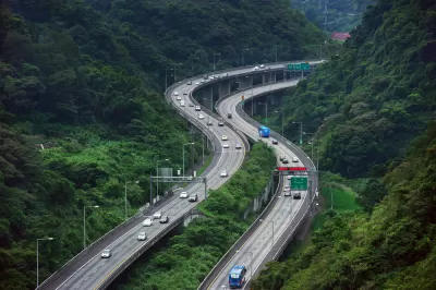
Something similar is happening in the transportation engineering field. Until recently, engineers evaluated transport system quality based on just one factor, traffic congestion delay, using an indicator called roadway level-of-service (LOS), which measures the ratio of a roadway's peak-period traffic volume to its capacity, using letter grades from A to F, just like elementary school, which implies that more roadway capacity is always better.
Highway Level of Service (LOS) Ratings
|
LOS |
Description |
Speed (mph) |
Flow(veh./hour/lane) |
(veh./mile) |
|
A |
Traffic flows at or above posted speed limit. Motorists have complete mobility between lanes. |
Over 60 |
Under 700 |
Under 12 |
|
B |
Slightly congested, with some impingement of maneuverability. |
57-60 |
700-1,100 |
12-20 |
|
C |
Ability to pass or change lanes constrained. Posted speeds maintained but roads are close to capacity. This is the target LOS for most urban highways. |
54-57 |
1,100-1,550 |
20-30 |
|
D |
Speeds somewhat reduced, vehicle maneuverability limited. Typical urban peak-period highway conditions. |
46-54 |
1,550-1,850 |
30-42 |
|
E |
Flow becomes irregular, speed vary and rarely reach the posted limit. This is considered a system failure. |
30-46 |
1,850-2,200 |
42-67 |
|
F |
Flow is forced, with frequent drops in speed to nearly zero mph. Travel time is unpredictable. |
Under 30 |
Unstable |
67-Maximum |
This table summarizes roadway Level of Service (LOS) ratings, an indicator of congestion intensity.
This significantly affects transportation and urban planning decisions, and therefore our lives. In practice, the results are often perverse: this indicator favors wider roads with higher design speeds, although this degrades walking and cycling conditions (called the barrier effect), and discourages infill development (because it can increase local congestion, although by reducing total vehicle trips it tends to reduce regional congestion costs) despite resulting undesirable impacts associated with automobile dependency and sprawl, such as increased transportation costs, accidents and pollution emissions.
There are growing efforts within the transportation engineering profession to reform these practices, so transport system performance evaluation considers a wider range of impacts and modes, but progress has been slow; roadway LOS continues to dominate the planning process. Recently passed California SB743 turns these indicators around: it introduces a process that measures the degree that a planning decision reduces total vehicle travel; it assumes that less rather than more vehicle travel is our ultimate planning goals.
Unsurprisingly, this has stimulated considerable debate on the Institute of Transportation Engineers (ITE) website, which is unfortunately only available to members. Let me share some highlights.
Critics of change argue that, since most travel is currently by automobile, efforts to change travel patterns must be inefficient, harmful to residents and businesses, and futile. I believe that these arguments are inappropriate and outdated.
Below are six reasons that I believe that transportation professionals should shift from evaluating urban transportation system performance based primarily on roadway level-of-service to using more comprehensive (considering impacts other than congestion) and multi-modal (besides automobile travel) indicators.
1. Measures the wrong thing
Roadway LOS only measures automobile travel conditions, but vehicle travel is seldom an end in itself, the ultimate goal of most transportation is accessibility to desired goods and services. Certainly, peak-period automobile travel speeds affect accessibility, but so do other factors such as the convenience and speed of walking, cycling and public transit, transport network connectivity, and land use accessibility, which is affected by development density and mix. There are often trade-offs between these factors, so efforts to improve roadway LOS ratings often reduce other forms of accessibility, for example, by blocking pedestrian access (and therefore transit access, since most transit trips include walking links) and discouraging compact, infill development which improve land use accessibility.
2. Current measurement tools are inadequate and biased
Roadway LOS is evaluated using models which predict how a particular planning decision, such as a new building or roadway design, will affect traffic volumes and roadway capacity, but a dirty little secret is that these models are inaccurate. For example, they incorporate assumptions about the number of peak-period trips generated by a particular type of development which are based on trip generation surveys that where mostly performed in automobile dependent suburban areas, because such sites are easiest to study. Recent studies indicate that in transit-oriented developments (TODs), trip generation rates are half as high as most models assume. Fortunately, there are good efforts to improve these models, but most models continue to underestimate TDM and smart growth trip reduction impacts.
Also, we know that urban traffic congestion tends to maintain equilibrium (also called triple convergence): it increases to the point that travelers forego some peak-period trips. As a result, efforts to reduce urban congestion by expanding roads are doomed to fail because the additional capacity soon fills with generated traffic. Few traffic models accurately incorporate congestion delay “feedback,” they simply extrapolate past traffic growth into the future and so exaggerate future congestion costs and the benefits or roadway expansion.
3. Changing travel demands
In most developed countries, automobile travel demand is peaking, while demand for alternative modes is growing, due to various demographic and economic trends including vehicle saturation, aging population, rising fuel prices, increasing urbanization, changing consumer housing preference, and growing concerns about affordability, health and environmental concerns. This is not to suggest that everybody wants to give up automobile travel completely, but good research indicates that at the margin (compared with their current travel patterns) many people want to drive less and rely more on walking, cycling, public transit and telework, and live in more accessible and multi-modal communities, provided that those alternatives are convenient, comfortable, integrated and affordable.
To the degree that this is true, transportation professionals have a responsibility to change our planning and evaluation practices to better reflect future transport system users' demands. More comprehensive travel data, multi-modal LOS, complete streets policies, multi-modal funding reforms, transportation demand management, smart growth development policies (particularly parking policy reforms) are practical ways that we do this.
4. Better congestion solutions
Roadway LOS only measures congestion intensity, the degree that vehicle travel speeds decline during peak periods. It is incomplete because it fails to reflect congestion exposure, that is, the amount that residents must drive during peak periods, and therefore their total congestion costs. As mentioned in previous postings, compact, multi-modal cities tend to have more intense congestion (they rate worse measured by roadway LOS or the Travel Time Index) but residents experience less per capita congestion costs because they rely more on alternative modes and their trips are shorter, as illustrated in the following figure.
City Rankings Change Depending On Congestion Indicators

This has important implications for evaluating potential congestion reduction strategies. If evaluated using roadway LOS, bus-lanes, more connected roadways, and smart growth strategies look bad, but if evaluated using multi-modal LOS or per capita congestion costs (which recognize travel time savings to bus passengers and shorter trip distances), they look relatively effective because they reduce congestion. For this reason, I believe it is wrong to conclude that investing in transit, applying complete streets policies or encouraging infill development necessarily increases congestion.
For example, Levine, et al. (2012) found that urban density has about ten times as much influence on the number of destinations motorists can access in a given time period as a proportional increase in traffic speeds. Levinson (2013) found that taking into account peak-period traffic speeds (and therefore congestion delays) and travel distances, denser cities such as Los Angeles, San Francisco, New York have greater automobile job access than more sprawled cities such as Dallas, Houston and Atlanta. Kuzmyak (2012) found that residents of urban neighborhoods with good travel options, connected streets and more nearby services drive a third fewer daily miles and experience less congestion delays than otherwise similar residents in automobile-dependent communities. Similarly, comprehensive research by Ewing and Hamidi (2014) indicates that sprawl significantly increases the total time and money residents spend in transport: each 10% increase in their Sprawl Index increases average journey-to-work drive time by 0.5%.This all suggests that roadway LOS is not a very good indicator of overall accessibility.
This is good news overall. It expands the range of potential solutions to transport problems to include improvements to alternative modes, improved transport network connectivity, and more compact land use development, all of which can improve overall accessibility more than a marginal reduction in roadway LOS.
5. Automobile-oriented planning is inherently inefficient and unfair
An efficient and equitable transportation system must be diverse so that users can choose the best mode for each trip, including walking and cycling for neighborhood trips, transit for travel on congested urban corridors, and automobiles for other types of trips. In any community, 20-40% of residents cannot or should not drive due to lack of driver's license, disability, low income, inebriation, or because they want exercise; failing to accommodate these trips deprives non-drivers of independent mobility and results in economically-excessive motor vehicle travel - vehicle miles that would be avoided if there were better travel options.
Evaluating transportation system performance based only on roadway LOS biases planning to favor automobile-oriented improvements, such as wider roads with higher design speeds, to the detriment of other modes, creating a self-fulfilling prophecy of increased automobile dependency and reduced travel options. There is good evidence that communities which improve walking, cycling and public transit experience shifts to those modes, indicating latent demand.
6. Multi-modal transportation increases safety
One unfortunate outcome of excessively automobile-dependent transport planning is high traffic fatality rates. In fact, the U.S. has the highest per capita traffic death rate among OECD countries, which can be explained by high per capita vehicle mileage. Many congestion reduction strategies, such as wider roads with higher design speeds, tend to increase traffic risks (see Marshall and Garrick 2011). In contrast, communities that improve transport options tend to have significantly lower traffic death rates.
Safety is, of course, an important transport planning and engineering goal. Evaluating transportation system performance based on roadway LOS ignores the crash risks that result from roadway expansions, or described in a more positive way, more comprehensive and multi-modal evaluation can help identify the congestion reduction strategies that also help improve traffic safety and increase community health.
In summary
Here are six good reasons that our profession should shift from evaluating urban transportation system performance using roadway LOS to more comprehensive and multi-modal transport system performance evaluation. To support these arguments, I provided good, peer reviewed research indicating that more comprehensive and multi-modal evaluation can better serve transport system users, just as a patient might ask his or her physician to evaluate a variety of health factors.
The table below is my attempt to illustrate this issue. It illustrates the scope of analysis used in conventional urban transport planning that relies on roadway LOS (blue squares), and the broader scope of modes and impacts that I believe should be considered in the planning process to better reflect transport system users’ demands and planning goals.
Scope of Transportation Planning Evaluation

What do you think? Should we change? If not, why?
For More Information
ADB (2009), Changing Course: A New Paradigm for Sustainable Urban Transport, Asian Development Bank.
Richard Dowling, et al. (2008), Multimodal Level Of Service Analysis For Urban Streets, NCHRP Report 616, Transportation Research Board.
Eric Dumbaugh (2012), Rethinking the Economics of Traffic Congestion, Atlantic Cities.
GIZ (2011), Changing Course in Urban Transport- An Illustrated Guide, Sustainable Urban Transport Project Asia and GIZ.
John LaPlante (2010), “The Challenge of Multi-modalism; Theodore M. Matson Memorial Award,” ITE Journal, Vol. 80, No. 10, October, pp. 20-23.
Todd Litman (2013), “The New Transportation Planning Paradigm,” ITE Journal, Vo. 83, No. 6, pp. 20-28.
Todd Litman (2014), Toward More Comprehensive and Multi-modal Transport Evaluation, Victoria Transport Policy Institute; summarized in JOURNEYS, September 2013, pp. 50-58.


*Video: Explaining Vehicle Miles Traveled (VMT)
Conventional planning evaluates transport system performance car-centric indicators such as roadway Level-of-Service (LOS). Many jurisdictions are shifting to Vehicle Miles Traveled (VMT), which supports multimodal planning and Smart Growth policies.

Conservatives’ Decongestion Pricing Flip-Flop
When it comes to solving traffic problems, the current federal administration is on track for failure, waste, and hypocrisy.

Why Traffic Never Gets Better
Despite abundant research showing that roadway expansions provide limited congestion relief and increase long-term traffic problems, they still occur due to wishful thinking: advocates claim that “this” project is different.

Maui's Vacation Rental Debate Turns Ugly
Verbal attacks, misinformation campaigns and fistfights plague a high-stakes debate to convert thousands of vacation rentals into long-term housing.

Planetizen Federal Action Tracker
A weekly monitor of how Trump’s orders and actions are impacting planners and planning in America.

In Urban Planning, AI Prompting Could be the New Design Thinking
Creativity has long been key to great urban design. What if we see AI as our new creative partner?

King County Supportive Housing Program Offers Hope for Unhoused Residents
The county is taking a ‘Housing First’ approach that prioritizes getting people into housing, then offering wraparound supportive services.

Researchers Use AI to Get Clearer Picture of US Housing
Analysts are using artificial intelligence to supercharge their research by allowing them to comb through data faster. Though these AI tools can be error prone, they save time and housing researchers are optimistic about the future.

Making Shared Micromobility More Inclusive
Cities and shared mobility system operators can do more to include people with disabilities in planning and operations, per a new report.
Urban Design for Planners 1: Software Tools
This six-course series explores essential urban design concepts using open source software and equips planners with the tools they need to participate fully in the urban design process.
Planning for Universal Design
Learn the tools for implementing Universal Design in planning regulations.
planning NEXT
Appalachian Highlands Housing Partners
Mpact (founded as Rail~Volution)
City of Camden Redevelopment Agency
City of Astoria
City of Portland
City of Laramie