


“For the historic cartographile, Christmas may have come late, but here it is,” writes Daniel Stuckey.
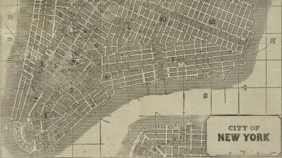
Matt Knutzen announces that the New York Public Library (NYPL) recently released over 20,000 cartographic works from the NYPL's Lionel Pincus & Princess Firyal Map Division to the public…for free, high resolution download…under a Creative Commons CC0 1.0 Universal Public Domain Dedication.
“We believe these maps have no known US copyright restrictions,” says a blog post by Knutzen on the NYPL website.
Among the maps released to the public: “1,100 maps of the Mid-Atlantic United States and cities from the 16th to 19th centuries, mostly drawn from the Lawrence H. Slaughter Collection; a detailed collection of more than 700topographic maps of the Austro-Hungarian empire created between 1877 and 1914; a collection of 2,800 maps from state, county and city atlases (mostly New York and New Jersey); a huge collection of more than10,300 maps from property, zoning, topographic, but mostly fire insurance atlases of New York City dating from 1852 to 1922; and an incredibly diverse collection of more than 1,000 maps of New York City, its boroughs and neighborhoods, dating from 1660 to 1922, which detail transportation, vice, real estate development, urban renewal, industrial development and pollution, political geography among many, many other things.”
"It means you can have the maps, all of them if you want, for free, in high resolution. We’ve scanned them to enable their use in the broadest possible ways by the largest number of people."
Writing for Motherboard, Daniel Stuckey provides further insight on how someone with an interest in historic maps might make use of this bounty: “Combined with its existing historical GIS program, the NYPL wants its users to engage with the maps, and allows them to warp (fitting together based on corresponding anchor points) and overlay the historic maps with modern geoweb services like Google and Open Street Map.”
FULL STORY: Open Access Maps at NYPL


How the National Park Service Uses GIS
A new book demonstrates how the National Park Service uses GIS technology to meet its mission and showcases a selection of maps used for effectively managing national parks.
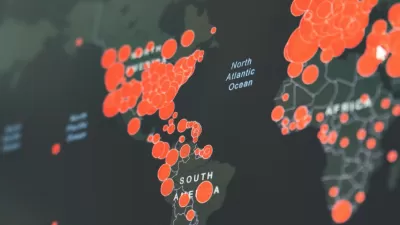
Visualizing the Coronavirus Pandemic
Mapping of the crisis is producing a fascinating and important trove of cartographic records.

Friday Funny: Cartographers Are Hiding an Idyllic Continent
The rest of the world would only spoil it for the mapmakers.

Study: Maui’s Plan to Convert Vacation Rentals to Long-Term Housing Could Cause Nearly $1 Billion Economic Loss
The plan would reduce visitor accommodation by 25,% resulting in 1,900 jobs lost.

North Texas Transit Leaders Tout Benefits of TOD for Growing Region
At a summit focused on transit-oriented development, policymakers discussed how North Texas’ expanded light rail system can serve as a tool for economic growth.

Using Old Oil and Gas Wells for Green Energy Storage
Penn State researchers have found that repurposing abandoned oil and gas wells for geothermal-assisted compressed-air energy storage can boost efficiency, reduce environmental risks, and support clean energy and job transitions.

Private Donations Propel Early Restoration of Palisades Playground
Los Angeles has secured over $1.3 million in private funding to restore the Pacific Palisades playground months ahead of schedule, creating a modern, accessible space that supports community healing after recent wildfires.

From Blight to Benefit: Early Results From California’s Equitable Cleanup Program
The Equitable Community Revitalization Grant (ECRG) program is reshaping brownfield redevelopment by prioritizing projects in low-income and environmental justice communities, emphasizing equity, transparency, and community benefits.

Planting Relief: Tackling Las Vegas Heat One Tree at a Time
Nevada Plants, a Las Vegas-based nonprofit, is combating the city’s extreme urban heat by giving away trees to residents in underserved neighborhoods, promoting shade, sustainability, and community health.
Urban Design for Planners 1: Software Tools
This six-course series explores essential urban design concepts using open source software and equips planners with the tools they need to participate fully in the urban design process.
Planning for Universal Design
Learn the tools for implementing Universal Design in planning regulations.
Ascent Environmental
Borough of Carlisle
Institute for Housing and Urban Development Studies (IHS)
City of Grandview
Harvard GSD Executive Education
Toledo-Lucas County Plan Commissions
Salt Lake City
NYU Wagner Graduate School of Public Service