


The creator of the TED conference has teamed up with Esri to develop an innovative interactive exhibit and online mapping tool to compare 16 global cities along 16 data points, including: population density, open space, and traffic.
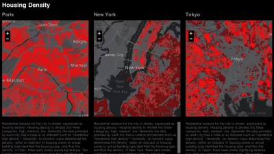
Richard Saul Wurman, the creator of the TED conference, has been interested in being able to compare cities at the same scale for more than 50 years. But only recently was he able to create a means to effectively, and attractively, display comparative patterns.
Wurman, Jon Kamen of Radical Media, and Esri president Jack Dangermond, have together created the Urban Observatory, "an immersive exhibit featuring standardized comparative data on over 16 cities. Zoom in on one city map and other cities will simultaneously zoom in at the same scale, making it possible to compare data on traffic density, vegetation, residential land use, and so on," says Ariel Schwartz.
"The Observatory features 16 data sets in five categories: work, movement, people, public, and systems. 'It’s shocking that it hasn’t been done 40 years ago, 50 years ago,' says Wurman."
FULL STORY: The Urban Observatory: A New Way To Compare Cities, From The Creator Of TED


Washington DC Launches Open Data Chatbot
City data is now available literally at the public’s fingertips, no data analytics skills required.

Esri Sets Up COVID-19 GIS Hub
The planning profession can contribute to the worldwide fight to control the spread of COVID-19. GIS technology, for instance, allows real-time monitoring of the pandemic.
Esri App Makes Data Visualization Easy
A wealth of pre-authored policy maps lets users access data to explore public policy issues.

Trump Administration Could Effectively End Housing Voucher Program
Federal officials are eyeing major cuts to the Section 8 program that helps millions of low-income households pay rent.

Planetizen Federal Action Tracker
A weekly monitor of how Trump’s orders and actions are impacting planners and planning in America.

Ken Jennings Launches Transit Web Series
The Jeopardy champ wants you to ride public transit.

California Invests Additional $5M in Electric School Buses
The state wants to electrify all of its school bus fleets by 2035.

Austin Launches $2M Homelessness Prevention Fund
A new grant program from the city’s Homeless Strategy Office will fund rental assistance and supportive services.

Alabama School Forestry Initiative Brings Trees to Schoolyards
Trees can improve physical and mental health for students and commnity members.
Urban Design for Planners 1: Software Tools
This six-course series explores essential urban design concepts using open source software and equips planners with the tools they need to participate fully in the urban design process.
Planning for Universal Design
Learn the tools for implementing Universal Design in planning regulations.
Ada County Highway District
Clanton & Associates, Inc.
Jessamine County Fiscal Court
Institute for Housing and Urban Development Studies (IHS)
City of Grandview
Harvard GSD Executive Education
Toledo-Lucas County Plan Commissions
Salt Lake City
NYU Wagner Graduate School of Public Service