


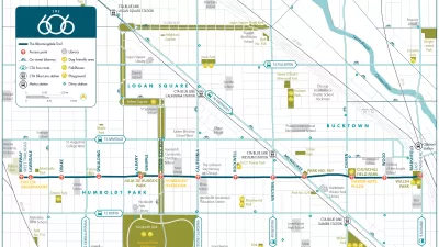
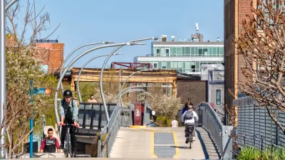
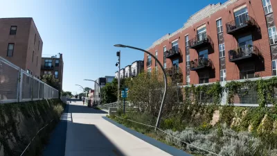
Final plans for what will become the longest elevated park in the world where unveiled this week in Chicago. The 2.7-mile rail-to-trail conversion has been branded as The 606, a nod to the zip code digits shared by the neighborhoods along its route.
"The planned 2.7-mile Bloomingdale Trail and five linked parks -- envisioned as an elevated pedestrian and bicycling corridor splashed with artwork and landscaping -- will assume a new, overarching identity Tuesday when the multi-use recreation system assumes a fresh moniker: The 606." reports Kathy Bergen. "The 606 label represents something virtually all city residents share -- the first three digits of Chicago ZIP codes, which planners hope will connote unity and links among neighborhoods."
In preparation for the project's August groundbreaking, the final plans and implementation schedule were presented at a public meeting held Tuesday. "To start, 38 bridges along the tracks will have to be repaired and rehabilitated, which will result in the some weekend road closures including Ashland, Western and Milwaukee avenues," reports Victoria Johnson. "Attendees also got sneak previews of other plans for The 606 [PDF], including a skate park, event center and stage and an observatory designed to line up with the setting sun."
"The development of a project name came about to dispel confusion surrounding the trail, which will run atop an abandoned 16-foot-high rail bed that runs above Bloomingdale Avenue, which is about 1800 [sic] north," says Bergen. "It stretches from Ashland Avenue on the east to Ridgeway Avenue on the west, linking Bucktown, Wicker Park, Logan Square and Humboldt Park."
"Lots of people thought it was in Bloomingdale, Ill., or many times people would call it the Bloomington Trail," said Beth White, director of the Trust for Public Land's Chicago office.
FULL STORY: Next step for Bloomingdale Trail: Creating an identity

Meet the 606: Chicago's New Elevated Bikeway and Park
Following in the footsteps of the High Line in New York City, Chicago opened a 2.7-mile elevated park, which has already been extremely popular in its first week. Here we round up the initial reactions to The 606, as the new park is called.
Don't Call it The 606: Chicago's Popular Linear Park Gets a New Name
The Chicago Park District wants to be extra sure we're all clear on this.
More Cities Pressing Pause on Development as Gentrification, Displacement Concerns Persist
Chicago and Atlanta both approved development moratoriums in areas surrounding new urban amenities this year. Other cities could soon add to the number.

What ‘The Brutalist’ Teaches Us About Modern Cities
How architecture and urban landscapes reflect the trauma and dysfunction of the post-war experience.

USDOT Revokes Approval for NYC Congestion Pricing
Despite the administration’s stated concern for the “working class,” 85 percent of Manhattan commuters use public transit to enter the city.
Tiny House Villages for Addressing Homelessness: An Interview with Yetimoni Kpeebi
One researcher's perspective on the potential of tiny homes and owner-built housing as one tool to fight the housing crisis.

Preserving Altadena’s Trees: A Community Effort to Save a Fire-Damaged Landscape
In the wake of the Eaton Fire, Altadena Green is working to preserve fire-damaged but recoverable trees, advocating for better assessment processes, educating homeowners, and protecting the community’s urban canopy from unnecessary removal.

The VW Bus is Back — Now as an Electric Minivan
Volkswagen’s ID. Buzz reimagines its iconic Bus as a fully electric minivan, blending retro design with modern technology, a 231-mile range, and practical versatility to offer a stylish yet functional EV for the future.

Investigation Reveals Just How Badly California’s Homeless Shelters are Failing
Fraud, violence, death, and chaos follow a billion dollar investment in a temporary solution that is proving ineffective.
Urban Design for Planners 1: Software Tools
This six-course series explores essential urban design concepts using open source software and equips planners with the tools they need to participate fully in the urban design process.
Planning for Universal Design
Learn the tools for implementing Universal Design in planning regulations.
Economic & Planning Systems, Inc.
UCLA Lewis Center for Regional Policy Studies
Mpact (formerly Rail~Volution)
Chaddick Institute at DePaul University
City of Piedmont, CA
Great Falls Development Authority, Inc.
HUDs Office of Policy Development and Research