


With Earth Engine, Google has compiled decades of images taken by Earth-observing satellites. The tool is meant for "scientists, independent researchers, and nations...to detect changes, map trends and quantify differences on the Earth's surface."
"Today, Google put out the Earth Engine, a fascinating tool that showcases a scrollable, zoomable time-lapse of the entire planet as seen by Landsat over the decades," writes Colin Schultz. According to Rebecca Moore, Engineering Manager with Google Earth Engine & Earth Outreach, the images paint "the most comprehensive picture of our changing planet ever made available to the public."
"The Landsat photos only go back to 1984," says Schultz, "but they show the dramatic ways in which the planet has changed in such a brief period of time. To help you get started, Google pulled out some highlights to look at, such as the drying of the Aral Sea or the deforestation of the Amazon. But the tool does show the whole planet (just the land, not the oceans), and there are many more cool things to be seen."
FULL STORY: 28-Year Satellite Time-Lapse Shows Exactly What We’re Doing to Our Planet


Friday Eye Candy: A 30-Year Timelapse Reveals Humanity's Expanding Footprint
The Google Timelapse feature has been updated. The only thing that stays the same is that everything changes.
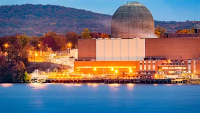
Google Inks Nuclear Power Deal
Tech giants are seeking out renewable energy to fuel power-hungry data centers and AI applications.

Google Seeks New Direction for Massive Housing Proposal
The company parted ways with its development partner, signaling a shift in strategy for a proposed 15,000-unit housing and office space project on Google-owned land in Silicon Valley.

Alabama: Trump Terminates Settlements for Black Communities Harmed By Raw Sewage
Trump deemed the landmark civil rights agreement “illegal DEI and environmental justice policy.”

Planetizen Federal Action Tracker
A weekly monitor of how Trump’s orders and actions are impacting planners and planning in America.

The 120 Year Old Tiny Home Villages That Sheltered San Francisco’s Earthquake Refugees
More than a century ago, San Francisco mobilized to house thousands of residents displaced by the 1906 earthquake. Could their strategy offer a model for the present?

In Both Crashes and Crime, Public Transportation is Far Safer than Driving
Contrary to popular assumptions, public transportation has far lower crash and crime rates than automobile travel. For safer communities, improve and encourage transit travel.

Report: Zoning Reforms Should Complement Nashville’s Ambitious Transit Plan
Without reform, restrictive zoning codes will limit the impact of the city’s planned transit expansion and could exclude some of the residents who depend on transit the most.

Judge Orders Release of Frozen IRA, IIJA Funding
The decision is a victory for environmental groups who charged that freezing funds for critical infrastructure and disaster response programs caused “real and irreparable harm” to communities.
Urban Design for Planners 1: Software Tools
This six-course series explores essential urban design concepts using open source software and equips planners with the tools they need to participate fully in the urban design process.
Planning for Universal Design
Learn the tools for implementing Universal Design in planning regulations.
Clanton & Associates, Inc.
Jessamine County Fiscal Court
Institute for Housing and Urban Development Studies (IHS)
City of Grandview
Harvard GSD Executive Education
Toledo-Lucas County Plan Commissions
Salt Lake City
NYU Wagner Graduate School of Public Service