


Dr. Marc Schlossberg of the University of Oregon developed a series of tools for mobile GIS devices, and set community members loose to use the technology to collect data about their streets and improve their neighborhood livability.
The Research
Dr. Marc Schlossberg (University of Oregon) developed a series of tools for mobile GIS devices. Communities used these tools to conduct street audits:
- School Environment Assessment tool (SEAT)
- Complete Streets Assesment tool (CSAT)
- Accessibility Audit Tool (AAT)
- Bicycle Assessment & Safety index tool (BASIT)
The Implications
Community-generated micro-scale data can inform decisionmaking in a unique way that could greatly expand the opportunities to craft and implement investments in active living policies.
Issue
Research on walking, the built environment, livability and healthy communities is a fairly recent area of inquiry, accelerated during the last ten years through our better understanding of the causes of climate change and by our national obesity epidemic. As research has progressed, so, too, has interest in developing ways to collect data at a very fine scale - in essence, to collect data at the streetscape level and link this data to active transportation (walking and biking) behavior. The last decade has given rise to more sophisticated yet easier to use geographic information systems (GIS) technology and to the use of digital maps by the public at large (e.g. MapQuest, GPS navigation, Google Maps). GIS can help planners and communities better understand the relationship between specific characteristics of the built environment and walking behavior, yet little data is available to make street-level assessments of the quality of the built environment as it relates to active transportation.
Moreover, traditional GIS mapping leaves little opportunity for average citizens – the built environment's daily users – to engage in either data collection, analysis or use to help create positive change.
Schlossberg's project directly aims to fill this gap by combining the sophistication of GIS technology with access and use by the general public. This multi-year project aimed to engage citizens around the country in more actively observing their environment, using community-based GIS to evaluate it, and, ultimately, to increase political support for changes that will increase the numbers of people who walk and bike.
Research
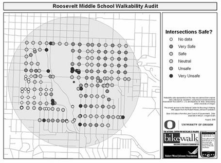
To assess the variety of elements that comprise a local transportation environment, Schlossberg developed a series of built environment audit tools with GIS technology that can be used in the field (mobile GIS). the most widely tested of these include the School Environment Assessment Tool (SEAT), which helps the national effort around safe routes to schools, and the Complete Streets Assessment Tool (CSAT), a tool to help implement the new national livability agenda. Other tools that were developed include the Accessibility Audit Tool (AAT), for use with issues related to the Americans with Disabilities Act, and the Bicycle Assessment & Safety Index Tool (BASIT).
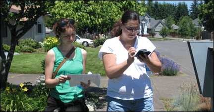
The overall motivation of this work is to give citizens access to powerful GIS technology so they can produce rich data and develop political coalitions to bring about change in their communities. Although the technology is sophisticated, the tools themselves are easy to use. Using a hand-held computer, participants load a local map, tap on the appropriate street segment or intersection and complete the data entry form that automatically appears, answering both objective and subjective questions on street characteristics.
These mobile GIS tools result in detailed, spatial data of the active transportation environment. Communities that use the tools retain the ability to monitor progress; articulate focused areas for needed improvements; prioritize activities; and develop appropriate interventions, whether they are engineering based (constructing new sidewalks or redesigning an intersection) or encouragement-based (working with school teachers and administrators to promote biking and walking). Workshops have been held in Oregon, Virginia, Wisconsin, Maryland and Minnesota and all have been received extremely positively. Current efforts also include transitioning the tool to more widely accessible technology, such as the iPhone and android phone platforms.
Implications
Our communities have few choices when it comes to transportation modes as much of the infrastructure has not been created with pedestrians and cyclists in mind. data used to make transportation decisions are usually macro in scale, yet the environment of importance for active transportation is very local and nuanced. therefore, as the nation attempts to move toward a livability framework for its transportation, environment and housing priority areas, there is a need to begin incorporating the micro-scale elements of the built environment into overall decision making.
Moreover, if walking and bicycling are to increase, a national cultural shift is needed. Engaging citizens in assessing and evaluating their built environment is one way this cultural shift can begin. the use of mobile mapping tools, such as those developed by Professor Schlossberg, is, therefore, important to collect detailed data and to apply it to help larger public constituencies understand and support policies and projects that allow more people to walk or bike as part of their daily lives.
Dr. Marc Schlossberg is an assistant professor of Planning, Public Policy, and Management (PPPM) at the University of Oregon. He holds a B.B.A. in Marketing from the University of Texas-Austin, an M.U.P. in Urban and Regional Planning from San José State University, and a Ph.D. in Urban, Technological, and Environmental Planning, with a certificate in Transportation Logistics planning from the University of Michigan.
This project was supported by a grant from the Oregon Transportation Research and Education Consortium.

Anybody For Some Duck Duck Goose?: Planning School, Semester Two Begins
On Friday, in the first week of my second semester of planning graduate school, we did the hokey-pokey. We put our right foot in, put our right foot out, put our right foot in, and then we shook it all about. We turned ourselves around. That was what it was all about. The demonstration was all about pointing out common ground and how people were rooted in order to approach problem solving and conflict resolution. It sounds a little squishy, I know. But it got the point across, and more important, it introduced the dance to one international student who had never heard of the hokey-pokey.

What ‘The Brutalist’ Teaches Us About Modern Cities
How architecture and urban landscapes reflect the trauma and dysfunction of the post-war experience.

Explore US Demographics With the New ACS Atlas Collection
Esri's new ACS Atlas Collection offers interactive applications that visualize the latest U.S. demographic and socio-economic data, enabling users to explore over 175 curated web maps across various thematic areas.
Manufactured Crisis: Losing the Nation’s Largest Source of Unsubsidized Affordable Housing
Manufactured housing communities have long been an affordable housing option for millions of people living in the U.S., but that affordability is disappearing rapidly. How did we get here?

Americans May Be Stuck — But Why?
Americans are moving a lot less than they once did, and that is a problem. While Yoni Applebaum, in his highly-publicized article Stuck, gets the reasons badly wrong, it's still important to ask: why are we moving so much less than before?
Research Shows More Roads = More Driving
A national study shows, once again, that increasing road supply induces additional vehicle travel, particularly over the long run.

Judge Halts Enforcement of Anti-Homeless Laws in Grants Pass
The Oregon city will be barred from enforcing two ordinances that prosecute unhoused residents until it increases capacity and accessibility at designated camping sites.

Advancing Sustainability in Los Angeles County Schools
The Los Angeles County Office of Education’s Green Schools Symposium brings together educators, students, and experts to advance sustainability in schools through innovative design, climate resilience strategies, and collaborative learning.

Using Old Oil and Gas Wells for Green Energy Storage
Penn State researchers have found that repurposing abandoned oil and gas wells for geothermal-assisted compressed-air energy storage can boost efficiency, reduce environmental risks, and support clean energy and job transitions.
Urban Design for Planners 1: Software Tools
This six-course series explores essential urban design concepts using open source software and equips planners with the tools they need to participate fully in the urban design process.
Planning for Universal Design
Learn the tools for implementing Universal Design in planning regulations.
City of Moreno Valley
Institute for Housing and Urban Development Studies (IHS)
City of Grandview
Harvard GSD Executive Education
NYU Wagner Graduate School of Public Service
City of Cambridge, Maryland
Newport County Development Council: Connect Greater Newport