


Shared streets, the contemporary vernacular used to describe streets that have been intentionally redesigned to remove exclusive boundaries for pedestrians, bicyclists, cars, etc., work well within a special set of conditions. It is, in reality, just a new way of describing the original use of streets (see this previous post for more on that). The most promising candidates for shared streets are those where traffic volumes are not too heavy, the route is not a critical corridor for vehicular through-traffic, activities and attractions along the street are plentiful, short distance connectivity is viable, and a critical mass of pedestrians (perhaps enough to pack sidewalks at certain times) exists. A shared street may also be suitable in places where there is a desire to induce such conditions; however, care must be taken to understand the larger network effects of shifting or slowing down vehicular traffic. But in some instances, seemingly unrelated changes to traffic patterns or the effects of a coincidental collection of the above conditions sometimes go unnoticed until a street that may have been all about cars gradually shifts into something I refer to as a “de facto shared street”.

Shared streets, the contemporary vernacular used to describe streets that have been intentionally redesigned to remove exclusive boundaries for pedestrians, bicyclists, cars, etc., work well within a special set of conditions. It is, in reality, just a new way of describing the original use of streets (see this previous post for more on that). The most promising candidates for shared streets are those where traffic volumes are not too heavy, the route is not a critical corridor for vehicular through-traffic, activities and attractions along the street are plentiful, short distance connectivity is viable, and a critical mass of pedestrians (perhaps enough to pack sidewalks at certain times) exists. A shared street may also be suitable in places where there is a desire to induce such conditions; however, care must be taken to understand the larger network effects of shifting or slowing down vehicular traffic. But in some instances, seemingly unrelated changes to traffic patterns or the effects of a coincidental collection of the above conditions sometimes go unnoticed until a street that may have been all about cars gradually shifts into something I refer to as a "de facto shared street".
A few weeks ago I referred to the chaos perceived by drivers at Gansevoort Plaza, in Manhattan's Meat Packing District, where pedestrians, bicyclists, cars, taxis, and buses mingle in an informal and unplanned way, as a de facto shared street. This is in contrast to the shared streets that have been more recently implemented by professional planners and engineers as a means of changing the way areas between property lines are perceived by people; that is, from streets designed for cars to public spaces equally accessible by everyone. While the newly redesigned Gansevoort Plaza was specifically crafted to enhance the shared street characteristics of the space while staying within the legal confines of New York City street design, its fundamental design criteria were based on the observed dynamic interaction amongst modes across the swath of historical Belgian block that many believe contributed to the area's growing appeal. In fact, when we began the conceptual design process, we based the original redesign concepts on that activity, with a little sprinkling of the traffic patterns observed in another Manhattan de facto shared street, Union Square West (photo further down the page). The end result is something that, due to being an early proof-of-concept in a city where aggressive change never comes easy, does not meet the letter, but rather the spirit, of shared street design.

Gansevoort Plaza in Manhattan's Meat Packing District Before Redesign
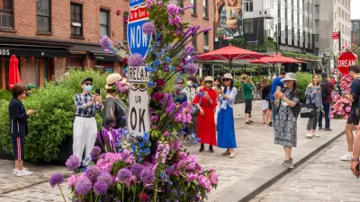
Over years of roaming through Manhattan, it turns out that the Big Apple is home to an interesting smattering of urban places that have, for various reasons, developed independently, to an extent, as de facto shared streets. Photos and short captions of some less obvious examples are provided below. Perhaps the most valuable take-away from this exercise is to demonstrate that the shared street concept is not nearly as foreign to the American psyche as some may say, and that if you look closely enough, you might find examples of de facto shared streets in your city too. Enjoy!

Broad Street in downtown Manhattan enjoys limited traffic due to security restrictions around Wall Street. The result is an area where pedestrians frequently spill out into the street, since sidewalks are narrow and frequently squeezed by scaffolding. Cars roll slowly and mix with pedestrians and bicyclists. The asphalt isn't so appealing, but the prospects are!

Wooster Street is an example of the de facto shared street feel of many SOHO streets. Low vehicular traffic volumes, big rushes of tourists on foot, and bumpy, Belgian block paving contribute to the effect.

Bloomberg Circle in Midtown is a quasi-public street (didn't research the consents here) where limited signage, minimal traffic, and strong desire lines (to cross the circle rather than walk around it) combine with pavers to create a de facto shared street.

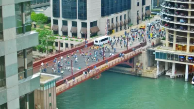
Union Square West is a bit chaotic since striping and spaces are so broad, but pedestrian volumes to and from the park result in an informal mingling of foot and vehicular traffic. There is a lot of opportunity to redesign this area, but even the current de facto shared street conditions were enough to build a friendly analogy and inspire roadway design elements of the new Gansevoort Plaza just a few blocks to the west.

‘Togetherness’ as a Synonym for ‘Transportation’
Transportation is a fundamental aspect of community cohesion, and should be considered a synonym for togetherness.

Opinion: It's Time To Put People Ahead of Cars in SoHo
A proposal from SoHo Broadway Initiative aims to prioritize pedestrian and bike infrastructure and discourage car traffic to make the neighborhood safer and more comfortable for the people who live and work there.
Chicago Dismantles Leland 'Slow Street' Three Months Early
Citing neighborhood concerns, the city is ending the Slow Street program on Leland Street as more parks and beaches reopen, but advocates want to see more permanent traffic calming measures.

Alabama: Trump Terminates Settlements for Black Communities Harmed By Raw Sewage
Trump deemed the landmark civil rights agreement “illegal DEI and environmental justice policy.”

Study: Maui’s Plan to Convert Vacation Rentals to Long-Term Housing Could Cause Nearly $1 Billion Economic Loss
The plan would reduce visitor accommodation by 25% resulting in 1,900 jobs lost.

Why Should We Subsidize Public Transportation?
Many public transit agencies face financial stress due to rising costs, declining fare revenue, and declining subsidies. Transit advocates must provide a strong business case for increasing public transit funding.

Paris Bike Boom Leads to Steep Drop in Air Pollution
The French city’s air quality has improved dramatically in the past 20 years, coinciding with a growth in cycling.

Why Housing Costs More to Build in California Than in Texas
Hard costs like labor and materials combined with ‘soft’ costs such as permitting make building in the San Francisco Bay Area almost three times as costly as in Texas cities.

San Diego County Sees a Rise in Urban Coyotes
San Diego County experiences a rise in urban coyotes, as sightings become prevalent throughout its urban neighbourhoods and surrounding areas.
Urban Design for Planners 1: Software Tools
This six-course series explores essential urban design concepts using open source software and equips planners with the tools they need to participate fully in the urban design process.
Planning for Universal Design
Learn the tools for implementing Universal Design in planning regulations.
Smith Gee Studio
Alamo Area Metropolitan Planning Organization
City of Santa Clarita
Institute for Housing and Urban Development Studies (IHS)
City of Grandview
Harvard GSD Executive Education
Toledo-Lucas County Plan Commissions
Salt Lake City
NYU Wagner Graduate School of Public Service