


This article from The Journal of American History looks at the history behind the human geography of New Orleans and how these residential patterns were affected by Hurricane Katrina.
"A spatial analysis helps clarify the relationships among race, class, and susceptibility to hurricane damage and death. Throughout the metropolitan area, 40 percent of the total population of 988,182 resided in areas that were under water on September 8, 2005.[19] Blacks outnumbered whites in that flooded area by over a 2-to-1 ratio, 257,375 to 121,262, even though whites outnumbered blacks metropolis-wide, 500,672 to 429,902. People of Asian and Hispanic ancestry numbered 9,240 and 11,830 among the flooded population and 25,552 and 49,342 among the total population, respectively. Thus, while one in every four whites' homes, one in four Hispanics' homes, and one in three Asians' homes flooded throughout the tri-parish metropolis of Orleans, Jefferson, and St. Bernard (24, 24, and 36 percent, respectively), close to two of every three African Americans' homes (60 percent) were inundated."
"The reason for the nuanced nature of the residential flooding statistics and their openness to multiple interpretations, is the complex historical geography explaining how current demographic patterns fell into place. Those reports that erroneously implied a strong positive correlation between elevation and class (and by extension race)-in other words, higher elevations hosted wealthier residents-reflected a failure to understand how the perceived technological neutralization of topography originally effected a negative relationship between the two: middle-class whites in the 1910s–1950s moved enthusiastically into the lowest-lying areas and excluded African Americans with racist deed covenants. White, prosperous Lakeview lies significantly lower than the poor, black Lower Ninth Ward. Additionally, oversimplified reports revealed a misunderstanding of the role of historical economic and environmental geographies, which explain the otherwise counterintuitive settlement of working-class African Americans along some of the highest land in New Orleans-the riverfront."
FULL STORY: An Ethnic Geography of New Orleans


Florida Considers Legalizing ADUs
Current state law allows — but doesn’t require — cities to permit accessory dwelling units in single-family residential neighborhoods.
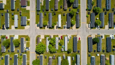
Manufactured Crisis: Losing the Nation’s Largest Source of Unsubsidized Affordable Housing
Manufactured housing communities have long been an affordable housing option for millions of people living in the U.S., but that affordability is disappearing rapidly. How did we get here?

Americans May Be Stuck — But Why?
Americans are moving a lot less than they once did, and that is a problem. While Yoni Applebaum, in his highly-publicized article Stuck, gets the reasons badly wrong, it's still important to ask: why are we moving so much less than before?

EV Chargers Now Outnumber Gas Pumps by Nearly 50% in California
Fast chargers still lag behind amidst rapid growth.

Affordable Housing Renovations Halt Mid-Air Amidst DOGE Clawbacks
HUD may rescind over a billion dollars earmarked for green building upgrades.

Has Anyone at USDOT Read Donald Shoup?
USDOT employees, who are required to go back to the office, will receive free parking at the agency’s D.C. offices — flying in the face of a growing research body that calls for pricing parking at its real value.
Urban Design for Planners 1: Software Tools
This six-course series explores essential urban design concepts using open source software and equips planners with the tools they need to participate fully in the urban design process.
Planning for Universal Design
Learn the tools for implementing Universal Design in planning regulations.
City of Moreno Valley
Institute for Housing and Urban Development Studies (IHS)
City of Grandview
Harvard GSD Executive Education
NYU Wagner Graduate School of Public Service
City of Cambridge, Maryland
Newport County Development Council: Connect Greater Newport