


The Int. Journal of Health Geographics publishes a study on how "GIS and cluster analysis makes it possible to objectively characterize urban neighborhoods and to select comparable and/or contrasting neighborhoods for community-based health studies."
"The neighborhood social and physical environments are considered significant factors contributing to children's inactive lifestyles, poor eating habits, and high levels of childhood obesity. Understanding of neighborhood environmental profiles is needed to facilitate community-based research and the development and implementation of community prevention and intervention programs. We sought to identify contrastive and comparable districts for childhood obesity and physical activity research studies. We have applied GIS technology to manipulate multiple data sources to generate objective and quantitative measures of school neighborhood-level characteristics for school-based studies. GIS technology integrated data from multiple sources (land use, traffic, crime, and census tract) and available social and built environment indicators theorized to be associated with childhood obesity and physical activity. We used network analysis and geoprocessing tools within a GIS environment to integrate these data and to generate objective social and physical environment measures for school districts. We applied hierarchical cluster analysis to categorize school district groups according to their neighborhood characteristics. We tested the utility of the area characterizations by using them to select comparable and contrastive schools for two specific studies."
[Editor's note: Reading this article in its entirety requires free registration.]
Thanks to Kira L. Ryskina

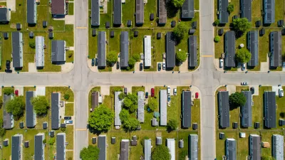
Manufactured Crisis: Losing the Nation’s Largest Source of Unsubsidized Affordable Housing
Manufactured housing communities have long been an affordable housing option for millions of people living in the U.S., but that affordability is disappearing rapidly. How did we get here?

Americans May Be Stuck — But Why?
Americans are moving a lot less than they once did, and that is a problem. While Yoni Applebaum, in his highly-publicized article Stuck, gets the reasons badly wrong, it's still important to ask: why are we moving so much less than before?
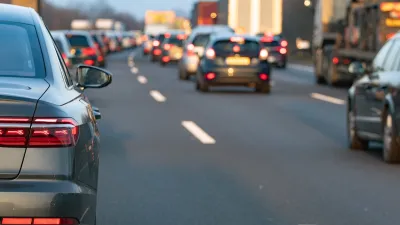
Research Shows More Roads = More Driving
A national study shows, once again, that increasing road supply induces additional vehicle travel, particularly over the long run.

Judge Halts Enforcement of Anti-Homeless Laws in Grants Pass
The Oregon city will be barred from enforcing two ordinances that prosecute unhoused residents until it increases capacity and accessibility at designated camping sites.

Advancing Sustainability in Los Angeles County Schools
The Los Angeles County Office of Education’s Green Schools Symposium brings together educators, students, and experts to advance sustainability in schools through innovative design, climate resilience strategies, and collaborative learning.

Using Old Oil and Gas Wells for Green Energy Storage
Penn State researchers have found that repurposing abandoned oil and gas wells for geothermal-assisted compressed-air energy storage can boost efficiency, reduce environmental risks, and support clean energy and job transitions.
Urban Design for Planners 1: Software Tools
This six-course series explores essential urban design concepts using open source software and equips planners with the tools they need to participate fully in the urban design process.
Planning for Universal Design
Learn the tools for implementing Universal Design in planning regulations.
City of Moreno Valley
Institute for Housing and Urban Development Studies (IHS)
City of Grandview
Harvard GSD Executive Education
NYU Wagner Graduate School of Public Service
City of Cambridge, Maryland
Newport County Development Council: Connect Greater Newport